What Are Rock Glaciers?
Rock glaciers are landforms associated with alpine periglacial landscapes around the world. They are key landforms in understanding climate change, hydrology, and the evolution of alpine terrain. The content of this page is derived from the guidelines for inventorying rock glaciers that were developed by the IPA Action Group on Rock Glacier Inventories and Kinematics (RGIK) to create a common framework for the baseline and practical concepts of rock glaciers that is globally consistent.
Understanding Rock Glaciers
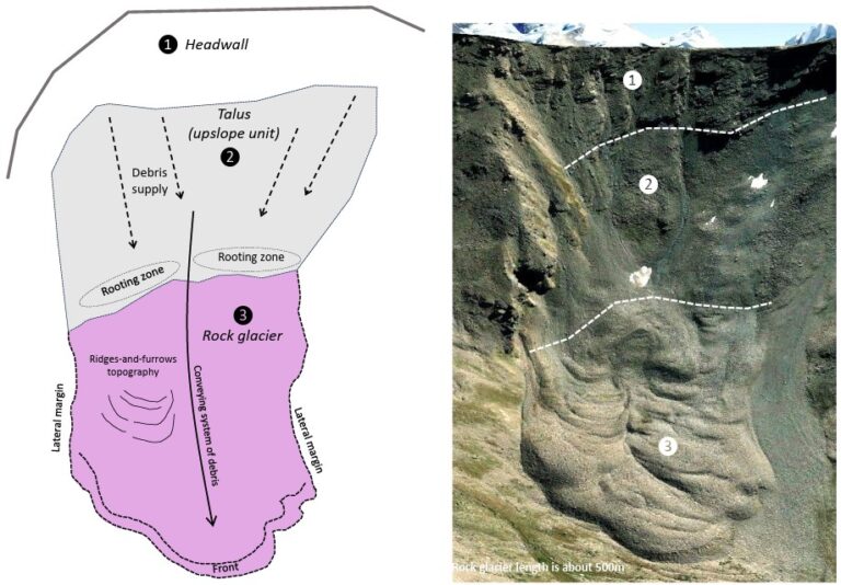
Rock glaciers are debris landforms generated by the former or current creep of frozen ground (permafrost), detectable in the landscape with the following morphologies: front, lateral margins and optionally ridge-and-furrow surface topography. Rock glacier (or permafrost) creep has to be understood here as a generic term referring to the variable combination of both internal deformation within the crystalline structure of the frozen ground (creep stricto sensu) and shearing in one or several horizons at depth. In a geomorphological slope sequence, rock glaciers are landforms conveying (or having conveyed) debris from an upslope area (rooting zone) towards their front. The size of clasts composing rock glaciers is not specified.
Key Geomorphological Features
The front is the steep terminal part of any rock glacier unit and a mandatory criterion. When the latter is in an active or transitional kinematic state, the rock glacier front is expected to be in motion down to a depth of about 15–30 m (permafrost creep). The uppermost moving frontal section is thus usually subject to reworking processes (e.g., crumbling), exposing “fresh” material at its surface. In most cases, the mobilized debris is deposited toward the bottom of the front and progressively overridden by the advancing rock glacier itself. The front of active and relict rock glaciers can exhibit a variety of longitudinal profiles. In the case of transitional rock glaciers, they may exhibit longitudinal profiles that lie between active and relict landforms and are therefore not explicitly described in the following frontal typologies. In the three first typologies, the front line of the rock glacier unit generally draws a curved downward, convex (lobate) morphology perpendicular to the principal rock glacier flow direction (Fig. 3A–C). In the truncated case, the front line has a non-lobate morphology (Fig. 3D).
Talus
The debris mobilized from the uppermost steeper section (>35–40° for active rock glaciers) builds up a talus accumulation of reduced extension at the foot of the rock glacier front. A talus-like front is delimited upslope by a front edge, which is quite sharp for active rock glaciers, but rounded for relict landforms.
Exaggerated Talus
If the rock glacier terminates in steep terrain, the reworking processes may create a frontal talus that is significantly greater than the thickness of the moving section of the rock glacier. An arbitrary value is given of 50m horizontal distance to standardise the process of outlining exaggerated rock glacier fronts with an extended outline.
Bulgy
A less common but distinct morphology characterized by a rounded and sometimes complex frontal topography, even for active rock glaciers.
Truncated
The front position is constrained by the topography (e.g., connection to steep torrential gully or overriding of rock cliff) and stays almost invariant over time. The front edge is usually sharp, and the front profile develops as an exaggerated talus.
Lateral margins are the continuation of the front on the sides of the rock glacier. Three different types of margins typically occur: talus-margins, levees and shear-margins, or a combination of these. Well-developed lateral margins may not always occur, particularly in the upper part of the landform.
Talus-margin
Designates a morphology similar to a talus-like front, which can even form an exaggerated talus and, in some uncommon cases, be truncated.
Levee
Is a former talus-margin that has ceased growing/building up, due to the lowering of the rock glacier surface. It could sometimes be confused with glacier lateral moraines, especially in the case of relict rock glaciers, and disentangling the two is not always possible.
Shear-margin
Is a shallow and elongated furrow that develops along the moving part of the rock glacier in association with shearing processes. It develops mostly at the inner bottom side of the levees and in the uppermost part of rock glaciers.
Ridges and furrows are pronounced, convex transverse or longitudinal surface undulations associated with the current or former cohesive flow of the rock glacier. This is an optional criterion. Transversal features are consecutive to compression, whereas longitudinal features reflect either flow convergence, or shearing, and deformation occurring between areas moving at different rates. These linear features should not be confused with transversal cracks and scarps which display a downward concavity associated with extensive flow and a high longitudinal velocity gradient usually associated with destabilization.
Categorization of Activity
The following conceptual categorization of rock glacier activity refers exclusively to the efficiency of sediment conveyance (expressed by the surface movement) at the time of observation. This categorization is tailored to work with RoGIs and compliant with the technical definition of rock glaciers. It should not be used to infer any ground ice content. The categories are still based on geomorphological indicators, which must be adapted regionally. If areal or point kinematic data are available, they should be integrated as a supplementary kinematic attribute and must be considered in order to assign the category of activity.
Active
Transitional
Relict
Spatial Connection to the Upslope Unit
Talus-connected
The rock glacier is part of a downslope sequence, including headwall – talus slope – rock glacier. In some cases, the talus slope is almost absent. The rock glacier unit is subjacent and connected to a talus slope unit, which is dominantly fed by rock-fall activity, but may also be fed by surface runoff, debris flow and/or avalanche events from the headwall unit. Sediment transfer across the talus slope unit can be operated by several interrelated processes. The area connecting the talus slope to the rock glacier is often characterized by a concave morphology, where, considering the landform history, the episodic to frequent development of long-lasting avalanche cones, snow/ice patches or even small glaciers/glacierets (relative to the rock glacier size) may occur. In the latter case, although the episodic disappearance of the glacier implies a lack of efficient sedimentary connection with the relevant upslope unit, the rock glacier is still classified as talus-connected.
Protalus ramparts are included in this category as “embryonic” rock glaciers if they are related to permafrost creep. They should not be confused with protalus-looking landforms related to (former or present) snow accumulation (i.e., pronival ramparts).
Debris-mantled slope-connected
The rock glacier lacks a (significant) headwall. The debris is dominantly produced by in-situ bedrock weathering (debris mantle) and gradually put into motion by shallow, surficial mass movement processes (e.g., solifluction) before developing into a rock glacier feature.
Landslide-connected
The rock glacier is situated in direct downslope connection of a landslide or lies on a large and active deep-seated gravitational slope deformation. In these situations, the talus slope unit is usually absent.
Glacier-connected
There is a continuity from a glacier, debris-covered glacier, or ice patch to a rock glacier feature. In the case of a glacier and ice patch, a debris-covered glacier transitional area always occurs between the debris-free ice and the rock glacier feature. The delimitation between the glacier or the ice patch section and the rock glacier section is not feasible without further direct or geophysical prospection. Embedded glacier ice within the rock glacier is likely to occur. Geomorphological features evidencing the presence of a debris-covered glacier upslope of the apparent rock glacier may be observed (e.g., crevasses, thermokarst, meltwater channels).
Glacier forefield-connected
The rock glacier develops within or from a (formerly) glaciated area. Interaction between the glacier or ice patch and the rock glacier feature is prevalent, but essentially restricted to phases of glacier advance (e.g., Little Ice Age). Embedded glacier ice within the rock glacier is possible. When receding, which is a common pattern today, the glacier has disconnected from the rock glacier or may have disappeared entirely. This category includes till-derived rock glaciers, which correspond to the classical debris rock glacier definition and to some push-moraines (glacitectonized frozen sediments).
Poly-connected
Two or more upslope connections (e.g., talus and glacier). The use of poly-connected should be restricted to cases where there is no obvious dominance of one connection type.
Other
Other types of geomorphological sequencing related to a rock glacier landform.
Interactive 3D Models of Rock Glaciers
Why Are Rock Glaciers Important?
Geomorphological Mapping
Rock glaciers are identified and mapped as functional or inherited (relict) landforms of the geomorphological landscape. In a geomorphological slope sequence, a functional rock glacier is a landform that currently conveys sediments from a rooting zone towards its front. In a geomorphological slope sequence, an inherited rock glacier is a landform that today no longer conveys sediments from a rooting zone towards its front, due to permafrost exhaustion. They are part of the mountain sediment cascade and as such contribute to control the pace of periglacial mountain landscape evolution. Enhancing the value of geomorphological heritage could also be the main motivation to compile a RoGI.
Proxy for Permafrost Occurrence
Functional rock glaciers are geomorphological indicators of the occurrence of permafrost. Even if it is accepted that functional rock glaciers may export perennially frozen ground outside of a permafrost prone area, they can be used to approximate the regional lower limit of the mountain permafrost belt and to validate spatial models of permafrost extent. Conversely, inherited (relict) rock glaciers are discriminative landforms of currently permafrost-free areas. Although functional rock glaciers attest to the occurrence of permafrost at depth, it must be considered that given the ongoing climate change, these features may gradually no longer reflect surface conditions favorable to permafrost occurrence.
Paleo-permafrost Studies
Inherited (relict) rock glaciers can be used as proxies for various paleo-permafrost extents. Discrimination between inherited and functional state is often difficult, making the integration of inherited landforms in a global inventory indispensable.
Climate Related Variable
Rock glacier movement is particularly sensitive to changing permafrost temperature. Updating and comparing inventories of functional rock glaciers, which include temporally well-constrained kinematic information, can be used to assess the impact of ongoing climate change on the mountain periglacial environment over regions.
Hydrological Significance
Functional rock glaciers are, by nature, ice (and water) storage features, which may play a prominent role in the hydrological regime of mountain catchments, especially in dry areas. RoGIs have been developed and/or used in particular for estimating their regional water-equivalent significance. In addition to being ice storage features, rock glaciers can affect water transit time and water chemistry in a catchment.
Geohazards
Functional rock glaciers may be the source of direct or indirect geohazards (e.g., destabilization, conveyance of loose debris into a gully) that may pose a risk to human activities and/or facilities (e.g., transport infrastructures, buildings, livelihoods). RoGIs can be used to locate and assess some potential geohazards at local to regional scales. It must be noted that in the context of infrastructure construction/maintenance, the information from RoGIs will not be sufficient to entirely understand the issues related to permafrost degradation. However, this information can provide insight into assessing the presence or absence of permafrost within study areas.